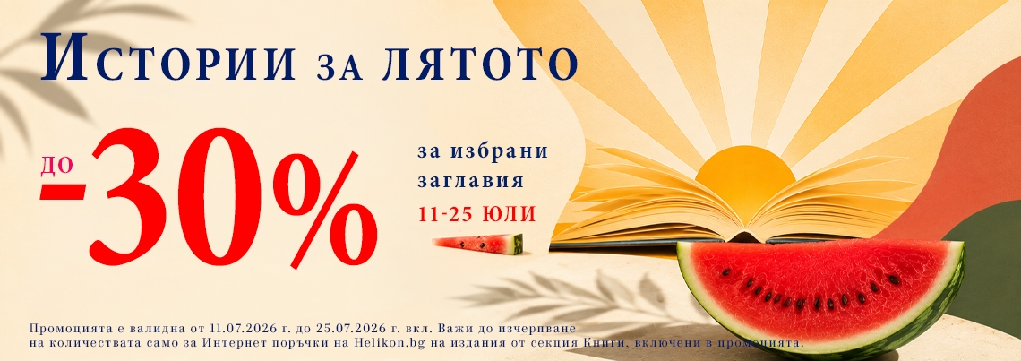
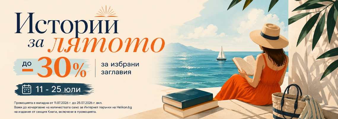

 -30%
-30%

Рейтингът се формира от продажбите в системата на Хеликон
Ледена жар - Кн.2 Скрито наследство
Илона Андрюс
14.83 € / 29.00 ЛВ.
Отстъпка -30%
Отстъпка -30%
10.38 € / 20.30 ЛВ.
-30%

Рейтингът се формира от продажбите в системата на Хеликон
Да стареем млади
Сергей Янг
14.83 € / 29.00 ЛВ.
Отстъпка -30%
Отстъпка -30%
10.38 € / 20.30 ЛВ.
-30%

Рейтингът се формира от продажбите в системата на Хеликон
Изцелението Шопенхауер (ново издание)
Ървин Д. Ялом
13.29 € / 25.99 ЛВ.
Отстъпка -30%
Отстъпка -30%
9.30 € / 18.19 ЛВ.
-30%

Рейтингът се формира от продажбите в системата на Хеликон
Не ви познавам
Теодора Димова
12.78 € / 25.00 ЛВ.
Отстъпка -30%
Отстъпка -30%
8.94 € / 17.49 ЛВ.
-30%

Рейтингът се формира от продажбите в системата на Хеликон
Апартаментът
Луси Фоли
11.25 € / 22.00 ЛВ.
Отстъпка -30%
Отстъпка -30%
7.87 € / 15.39 ЛВ.
-30%

Рейтингът се формира от продажбите в системата на Хеликон
Римска история
Теодор Момзен
17.90 € / 35.01 ЛВ.
Отстъпка -30%
Отстъпка -30%
12.53 € / 24.51 ЛВ.
-30%

Рейтингът се формира от продажбите в системата на Хеликон
Франки Фърбо
Уилям Уортън
3.83 € / 7.49 ЛВ.
Отстъпка -30%
Отстъпка -30%
2.68 € / 5.24 ЛВ.
-30%

Рейтингът се формира от продажбите в системата на Хеликон
Монахът, който продаде своето Ферари
Робин Шарма
6.14 € / 12.01 ЛВ.
Отстъпка -30%
Отстъпка -30%
4.29 € / 8.39 ЛВ.
-30%

Рейтингът се формира от продажбите в системата на Хеликон
Малазанска книга на мъртвите: Дом на вериги/ Сказание четвърто
Стивън Ериксън
14.32 € / 28.01 ЛВ.
Отстъпка -30%
Отстъпка -30%
10.02 € / 19.60 ЛВ.
-30%

Рейтингът се формира от продажбите в системата на Хеликон
Желязната воля
Орисън Марден
6.14 € / 12.01 ЛВ.
Отстъпка -30%
Отстъпка -30%
4.29 € / 8.39 ЛВ.
-25%

Рейтингът се формира от продажбите в системата на Хеликон
Пенсионният план
Сю Хинсенбъргс
12.78 € / 25.00 ЛВ.
Отстъпка -25%
Отстъпка -25%
9.58 € / 18.74 ЛВ.
-25%

Рейтингът се формира от продажбите в системата на Хеликон
Михаил Белчев. Ти ме повика, живот
Михаил Белчев, Албена Атанасова
17.90 € / 35.01 ЛВ.
Отстъпка -25%
Отстъпка -25%
13.42 € / 26.25 ЛВ.
-25%

Рейтингът се формира от продажбите в системата на Хеликон
Пак ще се срещнем в Тъкачната вила
Ане Якобс
14.27 € / 27.91 ЛВ.
Отстъпка -25%
Отстъпка -25%
10.70 € / 20.93 ЛВ.
 -25%
-25%

Рейтингът се формира от продажбите в системата на Хеликон
Заека богат
Джон Ъпдайк
14.32 € / 28.01 ЛВ.
Отстъпка -25%
Отстъпка -25%
10.74 € / 21.01 ЛВ.
-25%

Рейтингът се формира от продажбите в системата на Хеликон
Социокултурна психология: Наука на бъдещето
Майкъл Коул
6.14 € / 12.01 ЛВ.
Отстъпка -25%
Отстъпка -25%
4.60 € / 9.00 ЛВ.
-25%

Рейтингът се формира от продажбите в системата на Хеликон
Синът човешки
Протойерей Александър Мен
12.78 € / 25.00 ЛВ.
Отстъпка -25%
Отстъпка -25%
9.58 € / 18.74 ЛВ.
-25%

Рейтингът се формира от продажбите в системата на Хеликон
Български възрожденски книжовници от Македония
Колектив
5.09 € / 9.96 ЛВ.
Отстъпка -25%
Отстъпка -25%
3.81 € / 7.45 ЛВ.
-25%

Рейтингът се формира от продажбите в системата на Хеликон
Манастирска кухня
Димитър Мантов
9.99 € / 19.54 ЛВ.
Отстъпка -25%
Отстъпка -25%
7.49 € / 14.65 ЛВ.
-25%

Рейтингът се формира от продажбите в системата на Хеликон
Продуктивно охлювъдство
Атанас Германов, Петко Петков
5.11 € / 9.99 ЛВ.
Отстъпка -25%
Отстъпка -25%
3.83 € / 7.49 ЛВ.
-20%

Рейтингът се формира от продажбите в системата на Хеликон
Норвежки народни приказки Т.2
Петер Кристен Асбьорнсен и Йорген Му
18.92 € / 37.00 ЛВ.
Отстъпка -20%
Отстъпка -20%
15.13 € / 29.59 ЛВ.
-20%

Рейтингът се формира от продажбите в системата на Хеликон
Сватбеният търг Кн.2
Одри Карлан
10.22 € / 19.99 ЛВ.
Отстъпка -20%
Отстъпка -20%
8.17 € / 15.98 ЛВ.
-20%

Рейтингът се формира от продажбите в системата на Хеликон
Градината на самурая
Гейл Цукияма
12.27 € / 24.00 ЛВ.
Отстъпка -20%
Отстъпка -20%
9.81 € / 19.19 ЛВ.
-20%

Рейтингът се формира от продажбите в системата на Хеликон
Преди короната. Любовната история на Елизабет Втора и принц Филип
Флора Хардинг
8.69 € / 17.00 ЛВ.
Отстъпка -20%
Отстъпка -20%
6.95 € / 13.59 ЛВ.
-20%

Рейтингът се формира от продажбите в системата на Хеликон
Далечната Финландия отблизо
Роман Шац
9.20 € / 17.99 ЛВ.
Отстъпка -20%
Отстъпка -20%
7.36 € / 14.39 ЛВ.
-20%

Рейтингът се формира от продажбите в системата на Хеликон
Холографската вселена
Майкъл Толбот
12.78 € / 25.00 ЛВ.
Отстъпка -20%
Отстъпка -20%
10.22 € / 19.99 ЛВ.
 -20%
-20%

Рейтингът се формира от продажбите в системата на Хеликон
К.Г.Юнг - Лексикон
Дарил Шарп
6.14 € / 12.01 ЛВ.
Отстъпка -20%
Отстъпка -20%
4.91 € / 9.60 ЛВ.
-20%

Рейтингът се формира от продажбите в системата на Хеликон
Разговарям с хората - жива съм
Кети Драгнева
2.05 € / 4.01 ЛВ.
Отстъпка -20%
Отстъпка -20%
1.64 € / 3.21 ЛВ.
-20%

Рейтингът се формира от продажбите в системата на Хеликон
Защо великите лидери не приемат Да за отговор
Майкъл Роберто
10.23 € / 20.01 ЛВ.
Отстъпка -20%
Отстъпка -20%
8.18 € / 16.00 ЛВ.
-15%

Рейтингът се формира от продажбите в системата на Хеликон
Чай, торти и убийства
Питър Боланд
14.32 € / 28.01 ЛВ.
Отстъпка -15%
Отстъпка -15%
12.17 € / 23.80 ЛВ.
-15%

Рейтингът се формира от продажбите в системата на Хеликон
Аз още броя дните (ново допълнено издание - твърда корица)
Георги Бърдаров
12.00 € / 23.47 ЛВ.
Отстъпка -15%
Отстъпка -15%
10.19 € / 19.93 ЛВ.
-15%

Рейтингът се формира от продажбите в системата на Хеликон
Корабът на децата
Марио Варгас Льоса
13.29 € / 25.99 ЛВ.
Отстъпка -15%
Отстъпка -15%
11.29 € / 22.08 ЛВ.
-15%

Рейтингът се формира от продажбите в системата на Хеликон
Изкуството да разказваме истории
Коул Нусбамър Нафлик
19.43 € / 38.00 ЛВ.
Отстъпка -15%
Отстъпка -15%
16.51 € / 32.29 ЛВ.
 -15%
-15%

Рейтингът се формира от продажбите в системата на Хеликон
Старобългарски език
Кирил Мирчев
5.11 € / 9.99 ЛВ.
Отстъпка -15%
Отстъпка -15%
4.34 € / 8.49 ЛВ.
-15%

Рейтингът се формира от продажбите в системата на Хеликон
Другата археология
Станислав Станилов
3.07 € / 6.00 ЛВ.
Отстъпка -15%
Отстъпка -15%
2.60 € / 5.09 ЛВ.
-15%

Рейтингът се формира от продажбите в системата на Хеликон
Семейна мъдрост от Монаха, който продаде своето ферари
Робин Шарма
6.14 € / 12.01 ЛВ.
Отстъпка -15%
Отстъпка -15%
5.21 € / 10.19 ЛВ.
-15%

Рейтингът се формира от продажбите в системата на Хеликон
Как да говорим така, че детето да слуша и да го слушаме така, че да говори
Адел Фабер; Илейн Мазлиш
10.00 € / 19.56 ЛВ.
Отстъпка -15%
Отстъпка -15%
8.50 € / 16.62 ЛВ.
-15%

Рейтингът се формира от продажбите в системата на Хеликон
SOFIA. Ciudad en cruce de caminos/ Historia y Museos
15.34 € / 30.00 ЛВ.
Отстъпка -15%
Отстъпка -15%
13.03 € / 25.48 ЛВ.
-10%

Рейтингът се формира от продажбите в системата на Хеликон
Кафене „Пъмпкин Спайс“. Книга за оцветяване
8.00 € / 15.65 ЛВ.
Отстъпка -10%
Отстъпка -10%
7.20 € / 14.08 ЛВ.
-10%

Рейтингът се формира от продажбите в системата на Хеликон
Първа помощ при бърнаут
Емили Балестерос
12.99 € / 25.41 ЛВ.
Отстъпка -10%
Отстъпка -10%
11.69 € / 22.86 ЛВ.
-10%

Рейтингът се формира от продажбите в системата на Хеликон
Българска енциклопедия на ВИНОТО (пето, актуализирано издание)
Ясен Бориславов; Веселина Маринова
40.00 € / 78.23 ЛВ.
Отстъпка -10%
Отстъпка -10%
36.00 € / 70.41 ЛВ.
-10%

Рейтингът се формира от продажбите в системата на Хеликон
Гледачката на таро от Версай
Аня Бергман
15.00 € / 29.34 ЛВ.
Отстъпка -10%
Отстъпка -10%
13.50 € / 26.40 ЛВ.
-10%

Рейтингът се формира от продажбите в системата на Хеликон
100 стихотворения
Тил Линдеман
20.45 € / 40.00 ЛВ.
Отстъпка -10%
Отстъпка -10%
18.40 € / 35.99 ЛВ.
-10%

Рейтингът се формира от продажбите в системата на Хеликон
Алхимията: символика и психология
Мари-Луиз фон Франц
8.18 € / 16.00 ЛВ.
Отстъпка -10%
Отстъпка -10%
7.36 € / 14.39 ЛВ.
-10%

Рейтингът се формира от продажбите в системата на Хеликон
Акордиране на човешката душа Т.1
Боян Боев
14.83 € / 29.00 ЛВ.
Отстъпка -10%
Отстъпка -10%
13.34 € / 26.09 ЛВ.
-10%

Рейтингът се формира от продажбите в системата на Хеликон
Методическо ръководство по математика за начални учители
Колектив
3.07 € / 6.00 ЛВ.
Отстъпка -10%
Отстъпка -10%
2.76 € / 5.40 ЛВ.
-10%

Рейтингът се формира от продажбите в системата на Хеликон
Кръстопътища по здрач Кн.10 от Колелото на времето
Робърт Джордан
14.31 € / 27.99 ЛВ.
Отстъпка -10%
Отстъпка -10%
12.87 € / 25.17 ЛВ.
-10%

Рейтингът се формира от продажбите в системата на Хеликон
Проблеми и тенденции при планиране развитието на териториалните системи Ч.1
Лиляна Василева и др.
5.62 € / 10.99 ЛВ.
Отстъпка -10%
Отстъпка -10%
5.05 € / 9.88 ЛВ.
-10%

Рейтингът се формира от продажбите в системата на Хеликон
И тълпата полудя
Сюзън Елизабет Филипс
10.00 € / 19.56 ЛВ.
Отстъпка -10%
Отстъпка -10%
9.00 € / 17.60 ЛВ.
-10%

Рейтингът се формира от продажбите в системата на Хеликон
Само за лятото
Аби Хименес
11.20 € / 21.91 ЛВ.
Отстъпка -10%
Отстъпка -10%
10.08 € / 19.71 ЛВ.

 -10%
-10%

Рейтингът се формира от продажбите в системата на Хеликон
Любовта виси на косъм
Луси Скор
12.50 € / 24.45 ЛВ.
Отстъпка -10%
Отстъпка -10%
11.25 € / 22.00 ЛВ.
-10%

Рейтингът се формира от продажбите в системата на Хеликон
Град от кости Кн.1 от поредицата Реликвите на смъртните
Касандра Клеър
8.64 € / 16.90 ЛВ.
Отстъпка -10%
Отстъпка -10%
7.77 € / 15.20 ЛВ.
-10%

Рейтингът се формира от продажбите в системата на Хеликон
Град от стъкло Кн.3 от Реликвите на смъртните
Касандра Клеър
9.15 € / 17.90 ЛВ.
Отстъпка -10%
Отстъпка -10%
8.23 € / 16.10 ЛВ.
-10%

Рейтингът се формира от продажбите в системата на Хеликон
Ангел с часовников механизъм Кн.1 от поредицата Адски устройства
Касандра Клеър
10.20 € / 19.95 ЛВ.
Отстъпка -10%
Отстъпка -10%
9.18 € / 17.95 ЛВ.
-10%

Рейтингът се формира от продажбите в системата на Хеликон
Капризите на сърцето
Сюзън Елизабет Филипс
7.11 € / 13.91 ЛВ.
Отстъпка -10%
Отстъпка -10%
6.39 € / 12.50 ЛВ.
-10%

Рейтингът се формира от продажбите в системата на Хеликон
Пустинния скорпион
Бранимир Събев
6.08 € / 11.89 ЛВ.
Отстъпка -10%
Отстъпка -10%
5.47 € / 10.70 ЛВ.
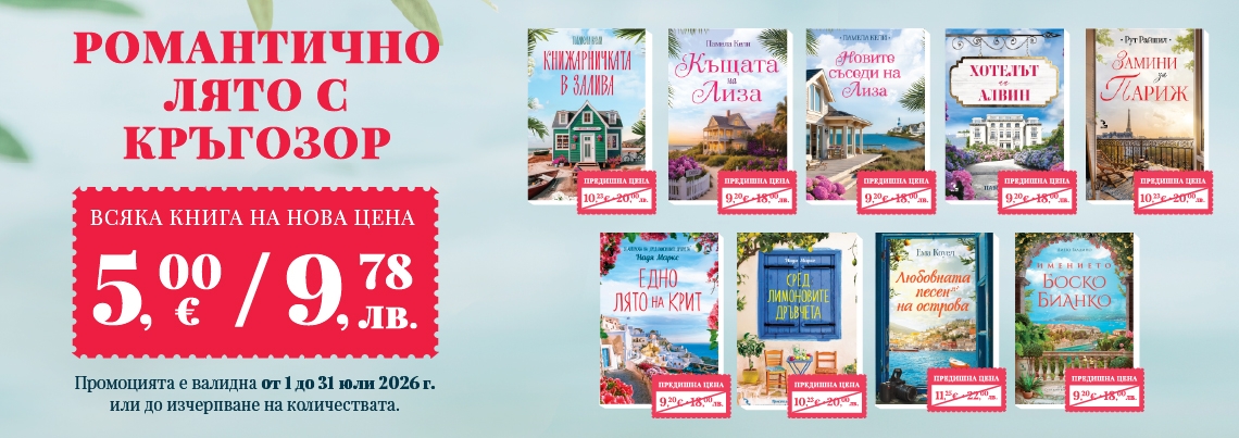
-46%

Рейтингът се формира от продажбите в системата на Хеликон
Новите съседи на Лиза
Памела Кели
9.20 € / 17.99 ЛВ.
Отстъпка -46%
Отстъпка -46%
5.00 € / 9.78 ЛВ.
-51%

Рейтингът се формира от продажбите в системата на Хеликон
Книжарничката в залива
Памела Кели
10.23 € / 20.01 ЛВ.
Отстъпка -51%
Отстъпка -51%
5.00 € / 9.78 ЛВ.
-46%

Рейтингът се формира от продажбите в системата на Хеликон
Едно лято на Крит
Надя Маркс
9.20 € / 17.99 ЛВ.
Отстъпка -46%
Отстъпка -46%
5.00 € / 9.78 ЛВ.
-46%

Рейтингът се формира от продажбите в системата на Хеликон
Къщата на Лиза
Памела Кели
9.20 € / 17.99 ЛВ.
Отстъпка -46%
Отстъпка -46%
5.00 € / 9.78 ЛВ.
-51%

Рейтингът се формира от продажбите в системата на Хеликон
Замини за Париж
Рут Райшил
10.23 € / 20.01 ЛВ.
Отстъпка -51%
Отстъпка -51%
5.00 € / 9.78 ЛВ.
-51%

Рейтингът се формира от продажбите в системата на Хеликон
Сред лимоновите дръвчета
Надя Маркс
10.23 € / 20.01 ЛВ.
Отстъпка -51%
Отстъпка -51%
5.00 € / 9.78 ЛВ.
-46%

Рейтингът се формира от продажбите в системата на Хеликон
Имението Боско Бианко
Диего Галдино
9.20 € / 17.99 ЛВ.
Отстъпка -46%
Отстъпка -46%
5.00 € / 9.78 ЛВ.
-46%

Рейтингът се формира от продажбите в системата на Хеликон
Хотелът на Алвин
Памела Кели
9.20 € / 17.99 ЛВ.
Отстъпка -46%
Отстъпка -46%
5.00 € / 9.78 ЛВ.
-56%

Рейтингът се формира от продажбите в системата на Хеликон
Любовната песен на острова
Ема Коуел
11.25 € / 22.00 ЛВ.
Отстъпка -56%
Отстъпка -56%
5.00 € / 9.78 ЛВ.

Рейтингът се формира от продажбите в системата на Хеликон
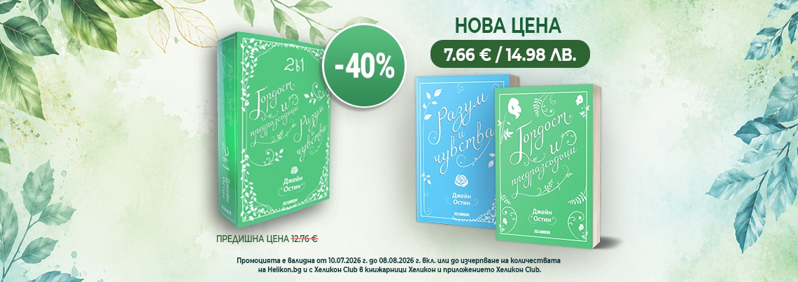
Джейн Еър (луксозно издание)
Шарлот Бронте
12.76 € / 24.96 ЛВ.

Рейтингът се формира от продажбите в системата на Хеликон
Разум и чувства
Джейн Остин
8.16 € / 15.96 ЛВ.

Рейтингът се формира от продажбите в системата на Хеликон
Ема (луксозно издание)
Джейн Остин
10.71 € / 20.95 ЛВ.

Рейтингът се формира от продажбите в системата на Хеликон
Малкият принц (малък формат - твърда корица)
Антоан дьо Сент- Екзюпери
5.09 € / 9.96 ЛВ.
-10%

Рейтингът се формира от продажбите в системата на Хеликон
Слънце изгрява
Ърнест Хемингуей
12.50 € / 24.45 ЛВ.
Отстъпка -10%
Отстъпка -10%
11.25 € / 22.00 ЛВ.

Рейтингът се формира от продажбите в системата на Хеликон
Нарцис и Голдмунд
Херман Хесе
11.25 € / 22.00 ЛВ.

Рейтингът се формира от продажбите в системата на Хеликон
Играта на стъклени перли
Херман Хесе
12.73 € / 24.90 ЛВ.

Рейтингът се формира от продажбите в системата на Хеликон
Любов по време на холера (луксозно издание)
Габриел Гарсия Маркес
16.87 € / 32.99 ЛВ.

Рейтингът се формира от продажбите в системата на Хеликон
Три безсмъртни класики: Към себе си (Марк Аврелий); Владетелят (Николо Макивели); Изкуството на войната (Сун Дзъ)
10.95 € / 21.42 ЛВ.

Рейтингът се формира от продажбите в системата на Хеликон
Бих умрял за теб и други изгубени истории /Луксозно издание/
Франсис Скот Фицджералд
12.76 € / 24.96 ЛВ.


Рейтингът се формира от продажбите в системата на Хеликон
Протокол "Хаос"
Жозе Родригеш душ Сантуш
12.95 € / 25.33 ЛВ.

Рейтингът се формира от продажбите в системата на Хеликон
Крос срещу Семейния убиец
Джеймс Патерсън
12.95 € / 25.33 ЛВ.

Рейтингът се формира от продажбите в системата на Хеликон
Краят на Уолтър Неш
Дейвид Балдачи
14.00 € / 27.38 ЛВ.

Рейтингът се формира от продажбите в системата на Хеликон
Тежестта на доказателствата
Майкъл Конъли
11.99 € / 23.45 ЛВ.


Рейтингът се формира от продажбите в системата на Хеликон
Шестото клеймо
Дан Браун
12.78 € / 25.00 ЛВ.

Рейтингът се формира от продажбите в системата на Хеликон
Шифърът на Леонардо
Дан Браун
12.78 € / 25.00 ЛВ.


Рейтингът се формира от продажбите в системата на Хеликон
Цифрова крепост
Дан Браун
10.22 € / 19.99 ЛВ.

Рейтингът се формира от продажбите в системата на Хеликон
Благотворителната вечер
Памела Кели
10.00 € / 19.56 ЛВ.

Рейтингът се формира от продажбите в системата на Хеликон
Забраненият плод
Джоджо Мойс
12.95 € / 25.33 ЛВ.

Рейтингът се формира от продажбите в системата на Хеликон
Лято в Ню Йорк
Алекс Астър
10.20 € / 19.95 ЛВ.

Рейтингът се формира от продажбите в системата на Хеликон
По същото време следващото лято
Аннабел Монахан
10.99 € / 21.49 ЛВ.

Рейтингът се формира от продажбите в системата на Хеликон
Всичко за любовта
Джоана Болури
10.00 € / 19.56 ЛВ.
-10%

Рейтингът се формира от продажбите в системата на Хеликон
Жестока любов
Колийн Хувър
9.70 € / 18.97 ЛВ.
Отстъпка -10%
Отстъпка -10%
8.72 € / 17.05 ЛВ.
-10%

Рейтингът се формира от продажбите в системата на Хеликон
Може би някой ден
Колийн Хувър
8.64 € / 16.90 ЛВ.
Отстъпка -10%
Отстъпка -10%
7.77 € / 15.20 ЛВ.

Рейтингът се формира от продажбите в системата на Хеликон
С дъх на канела (ново издание)
Никълъс Спаркс
11.25 € / 22.00 ЛВ.

Рейтингът се формира от продажбите в системата на Хеликон
Брегът на костенурките
Диего Галдино
9.20 € / 17.99 ЛВ.


Рейтингът се формира от продажбите в системата на Хеликон
Изтрити от лицето на земята
Джо Спейн
11.95 € / 23.37 ЛВ.

Рейтингът се формира от продажбите в системата на Хеликон
Сватбеният агент
Памела Кели
10.00 € / 19.56 ЛВ.

Рейтингът се формира от продажбите в системата на Хеликон
Балада за падащи дракони (с цветни порезки)
Сара А. Паркър
18.90 € / 36.97 ЛВ.


Рейтингът се формира от продажбите в системата на Хеликон
Изкуството да надхитриш кармата
Елисабет Бенавент
18.00 € / 35.20 ЛВ.

Рейтингът се формира от продажбите в системата на Хеликон
Преобразяването на света
Джеролд Сийгъл
23.00 € / 44.98 ЛВ.

Рейтингът се формира от продажбите в системата на Хеликон
Паста. 50 лесни рецепти
11.00 € / 21.51 ЛВ.

Рейтингът се формира от продажбите в системата на Хеликон
Пица. 50 лесни рецепти
11.00 € / 21.51 ЛВ.

Рейтингът се формира от продажбите в системата на Хеликон
Петронела Ябълкова: Бъбрива гъска и вещерска къща
Сабине Щединг
8.50 € / 16.62 ЛВ.

Рейтингът се формира от продажбите в системата на Хеликон
Хектор Фокс: Дръзкият полет
Астрид Шекълс
12.00 € / 23.47 ЛВ.
Рейтингът се формира от продажбите в системата на Хеликон
Забраненият плод
Джоджо Мойс
12.95 € / 25.33 ЛВ.

Рейтингът се формира от продажбите в системата на Хеликон
Силата на наричането II. Отвъд думите
Мирослава Митева
12.90 € / 25.23 ЛВ.

Рейтингът се формира от продажбите в системата на Хеликон
Любов в насрещното
Здрава Каменова
9.00 € / 17.60 ЛВ.

Рейтингът се формира от продажбите в системата на Хеликон
Нищо за губене
Джонатан Ангелов
12.90 € / 25.23 ЛВ.

Рейтингът се формира от продажбите в системата на Хеликон
Пътят на душите
Майкъл Нютън
9.00 € / 17.60 ЛВ.

Рейтингът се формира от продажбите в системата на Хеликон
Дон Кихот де Ла Манча
Мигел да Сервантес
3.04 € / 5.95 ЛВ.

Рейтингът се формира от продажбите в системата на Хеликон
Пипи Дългото чорапче
Астрид Линдгрен
5.60 € / 10.95 ЛВ.

Рейтингът се формира от продажбите в системата на Хеликон
Ние, врабчетата
Йордан Радичков
6.14 € / 12.01 ЛВ.

Рейтингът се формира от продажбите в системата на Хеликон
Подсъзнанието може всичко/ ново допълнено издание
Джон Кехоу
8.64 € / 16.90 ЛВ.

Рейтингът се формира от продажбите в системата на Хеликон
Жените от Нотр Дам
Ева Мария Баст
12.00 € / 23.47 ЛВ.

Рейтингът се формира от продажбите в системата на Хеликон
Хищници
Мелиса да Коста
14.00 € / 27.38 ЛВ.

Рейтингът се формира от продажбите в системата на Хеликон
Крадец на нощта
Холи Блек
16.00 € / 31.29 ЛВ.

Рейтингът се формира от продажбите в системата на Хеликон
Крокет и Емпанадия в Япония
Ана Онсина
12.95 € / 25.33 ЛВ.

Рейтингът се формира от продажбите в системата на Хеликон
Всичко започва от теб
Джилиан Турецки
11.99 € / 23.45 ЛВ.


Рейтингът се формира от продажбите в системата на Хеликон
Вяра /с цветни порезки/
Люси Елеазар
16.99 € / 33.23 ЛВ.

Рейтингът се формира от продажбите в системата на Хеликон
Мария Кюри в страната на науката
Ирен Коен-Янка, Клаудия Палмаручи
12.00 € / 23.47 ЛВ.

Рейтингът се формира от продажбите в системата на Хеликон